 Co., Ltd.")


MAS-RTU Wireless Remote Terminal

The MAS-RTU is a disaster monitoring terminal independently developed by gxun technology. it can support a variety of monitoring sensors, such as surface displacement, water level, rainfall, inclination angle, laser displacement, soil moisture content and other sensors, and can be customized and expanded. the system has intelligent on-duty functions such as independent collection and reporting, real-time early warning analysis and judgment, early warning sound and light and image linkage control, alarm and transmission.
Overview
The MAS-RTU disaster monitoring system adopts an integrated structure design, which can realize the integrated design of sensors, monitoring terminals, photovoltaic power supply systems, alarm linkage, etc., real-time monitoring and collection, and can be widely used in various monitoring points of geological disasters, such as collapse, Landslide, debris flow, displacement, soil moisture content, pore water seepage pressure, rainfall, surface water level and so on.
As the construction of geological disaster monitoring system involves many elements, wide scope, complex environment and large investment scale, at the same time, geological environment monitoring and accident emergency treatment need multi-party cooperation across regions and departments, so rational layout and overall planning are particularly important. Therefore, the main form of the current disaster monitoring system is an integrated RTU monitoring station, which connects various sensors through standard RTU equipment, collects and analyzes data in real time, and sends data to the data center through the operator network to complete data analysis and early warning processing.
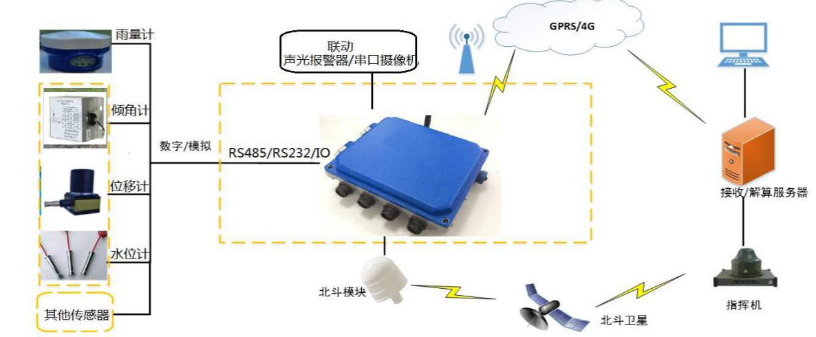
Fig.2 System block diagram
Characteristic:
- Reliability: The system can ensure long-term safe operation. The hardware and software in the system have protection mechanisms such as anti-crash to meet the reliability design requirements.
- Real-time: acquisition system real-time acquisition, local calculation and judgment, once the first time the local linkage early warning and image capture, the automatic adjustment of the acquisition frequency.
- Adaptability: The system has a variety of communication methods for backup and complementarity, which can ensure the early warning coverage area and has strong adaptability to the terrain environment.
- Expanding: the hardware and software of the system can be upgraded, the acquisition function can be increased, and the access management platform can be customized.
- Integrated structure design: monitoring, collection and transmission, early warning linkage, power supply, can be quickly laid and installed, reduce the difficulty and cost of on-site implementation.
- Operability: One-key operation site hardware equipment is simple to operate, easy to learn and master, suitable for mountainous outdoor environment.
Specifications
|
Name |
Parameters |
|
Number of channels |
4-channel data acquisition interface (vibrating wire, RS485, RS23, IO interface) |
|
Communication Mode |
4G (main)/Beidou (optional)/NB-IoT(M5310-A). |
|
Interface Function |
1. The device supports the function of sending data with different login information to more than three addresses. 2. The device has a remote clock automatic synchronization function. The device can judge whether the data is sent successfully and automatically reissue the data that has not been sent successfully. 3. The device has a self-test function, and regularly reports self-test data such as battery voltage, temperature, signal strength, and location information. 4. The monitoring equipment has the function of encrypted collection, and the encrypted collection period can be set. 5. The monitoring equipment has a threshold trigger function. If the monitoring data exceeds the threshold, it will be collected immediately and automatically reported. 6. The measuring equipment supports receiving and executing remote control instructions from the geological disaster prevention and control notification platform, including but not limited to remotely viewing and correcting the equipment time, viewing and setting the data transmission interval, viewing and setting the equipment threshold, collecting and viewing the current measured values, remotely restarting the equipment and regularly automatically returning or manually obtaining the real-time status of the equipment. 7. The monitoring equipment needs to be directly connected with the geological disaster prevention and control command platform in real time, and the message format meets the industry requirements (using MQTT protocol). 8. Data interface: with RS485 or RS232 interface, you can set the relevant parameters of the host through the port. |
|
GPS Function |
Support, accuracy ≤ 10m |
|
Working Temperature |
-20 ℃ ~ 65 ℃ |
|
Protection Level |
IP67 |
|
Endurance |
25 ℃ under no light, 30 days endurance (customizable) |
|
SD Card Capacity |
≥ 16GB, can store more than 3 years of original observation data, with insufficient space to automatically overwrite the old file function. |
|
Sensor Interface |
Support water level gauge, cable displacement meter, accelerometer, inclinometer, rain gauge, liquid level meter, laser range finder, soil temperature and humidity meter, temperature and humidity sensor; |
|
Linkage Interface |
Sound and light alarm, 200W pixel infrared serial camera (optional) |
|
Data Acquisition Mode |
Support automatic collection and upload transmission. |
|
Sampling Interval |
0S-24H |
|
Upload Interval |
0S-72H |
Related Information
Request for Quote