 Co., Ltd.")


Surface Displacement Monitoring System

The model SDMS surface displacement monitoring system is based on the technology of global navigation satellite system. The SDMS using highly integrated design, it is based on a high-precision multi-system board and can provide high-precision positioning. The integrated design improves the system's anti-interference and reliability. It is widely used in surface displacement monitoring in bridges, slopes, reservoirs, dams, earthquake disasters and other industries. The device has built-in GPRS\3G\4G communication module and data transmission unit. It integrates 30AH high-capacity lithium battery and solar power supply system. You just only need to connect external solar panels to the SDMS. The SDMS can be widely used for surface displacement monitoring and structural deformation monitoring, such as real-time monitoring of displacement and deformation of landslides, slope displacements, bridge deformations,reservoirs, dams, mines, geological disasters, etc.
Overview
Global Navigation Satellite System (GNSS), which generally refers to all satellite systems, including global and regional satellite navigation systems such as China's Beidou System (BDS), the United States GPS system, the Russian GLONASS system and the European Galileo system. The GNSS has the advantages of all-weather, full-time domain, high positioning accuracy, short measurement time, no need for visual communication between measuring stations, and the ability to simultaneously measure the three-dimensional coordinates of points. GNSS technology is a high-precision deformation monitoring technology that enables remote automated measurement.
Characteristic:
- High integration, integrated design, high precision and strong anti-interference ability;
- Just connect external solar panels to work, the system is more reliable;
- Low power consumption, device power consumption is less than 2W;
- Supports multiple transmission methods such as RS485\LoRa\4G\LAN;
- Simple installation and easy maintenance, large measuring range;
Application scenarios:
- Lateral and vertical deformation in dams, tailings, buildings, bridges etc.
- The stability of natural slopes, landslides, embankments, subsea marine sediments;
- Geological disaster monitoring;
System Component:
- SDMS mainly consists of all-in-one GNSS device, solar panels and installation poles. Data calculation can be done through hardware front-end networking or by transmitting data back to the server for background calculation.
Specifications
|
Type |
SDMS |
|
NavigationSystem |
BDS, GPS,GLONASS,Galileo |
|
Signal Tracking |
BDS:B1、B2; GPS:L1、L2; GLONASS:G1、G2; Galileo:E1、E5 |
|
Single Point Positioning Accuracy |
<1.5m |
|
RTK Positioning Accuracy |
Horizontal:±(10 +1×10⁻⁶×D)mm(GPS) ±(10 +0.5×0-6×D)mm(GPS+BDS) Vertical:±(2-0 +1×0-6×D)mm(GPS) ±(20 +0.5×0 6×D)mm(GPS+BDS) |
|
Static Positioning Accuracy |
Horizontal:±(2.0 +0.5×10⁻⁶×D)mm Vertical:±(4.0 + 0.5×10⁻⁶×D)mm |
|
Initialization Time |
1min |
|
Tnitial Reliability |
>99.9% |
|
Time for First Start |
Cold start:<50s Warm start:<30s HotStart: <15s |
|
Recapture Time for Lost Lock |
<2s |
|
Differential Data Format |
RTCM3.X |
|
Data Update Rate |
1Hz、2Hz、5Hz |
|
Data Format |
NMEA-0183/ RTCM2.X/ RTCM3.X |
|
Protocol |
RS232、RS485、TCP/IP |
|
Internal Storage |
100MB(Expandable) |
|
Built-in Lithium Battery |
12V30AH |
|
Operating Temperature |
-40℃~+70℃ |
|
Humidity |
100%Fully sealed, anti-condensation, floatable |
|
Dustproof and Waterproof |
IP67 |
|
Power Consumption |
<2W |
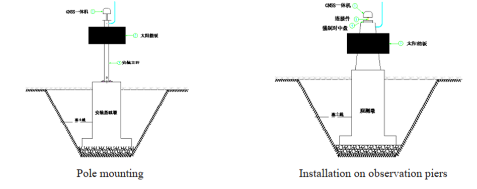
Installation Method:
Related Information
Request for Quote